
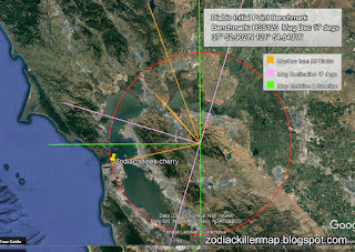
Mt Diablo Initial Point - Col, Leander Ransom - Zodiac Killer
MOUNT DIABLO SURVEY POINT
ESTABLISHES PROPERTY
BOUNDARIES IN CALIFORNIA AND NEVADA
By John W. Pettley, PLS
Ever wonder how your property corners were initially established? Just look to the top of Mount Diablo for the answer.
Mount Diablo is the starting point for the establishment of land boundaries throughout most of Northern California and all of Nevada. The summit is the location of the "Initial Point," the north/south meridian, and east/west baseline intersection point that is the basis for most property boundaries.
As part of the settlement of the Mexican War of 1846-1848, "ranchos," or private land holdings established during Spanish and Mexican rule, were honored by the U.S. Government under the Treaty of Guadelupe Hidalgo with Mexico.
These ranchos, which were primarily along coastal areas of present-day California and in the San Joaquin and Sacramento Valleys, covered 9 million acres, or 14,000 square miles. To delineate these private lands, the United States Deputy Surveyors were assigned to survey the rancho boundaries. During the 1850s more than 30 government survey parties were deployed.
http://www.mdshs.org/article.html
W121 54' 48" N37 51'30" - Mt Diablo Meridian

Comments
Post a Comment