Posts

Cherry and Maple Taxi - Paul Stines

Ok, So where Paul Stines stopped was the Presido Hill school that teaches Students in almost every lower school class have weekly excursions in the Presidio where they explore local plants and animals, learn about maps and navigation, and investigate Native American culture. https://www.presidiohill.org/academics/environmental-education

Zodiac Killer murder lines from Mt Diablo initial point

Image
Here the lines from Mt Diablo Initial Point, Dennings memorial.  I haven't noted distance and angle yet.  The Zodiacs bomb located proportionately to the calcs?

Zodiac Killer and UnaBomber similarities

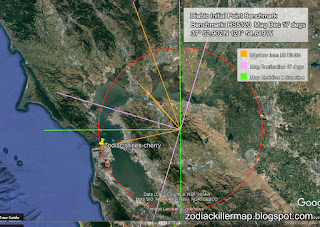
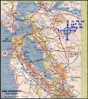
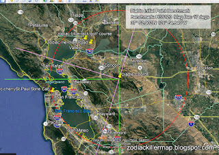
Considering Theo was anti development and the Devil mountain is the centralised initial point for cadastral boundaries used to create land allotments for the subdivision in building and destruction of forest land and wildlife, Theo holds a similar theme in The Zodiac philosophy, mathematics, bomb making, geodetic locations. The Zodiac and Theo hold similar themes in their murder with mathematics etc. The choice of location being Devil mountain and its cartography attributes on the Phillips 66 map. In 1967, Kaczynski's dissertation Boundary Functions [29] won the Sumner B. Myers Prize for Michigan's best math dissertation of the year. [8] Like Ted, Zodiac says humans are much more fun to hunt than animals. Mathematics, Bomb making, Cryptography. The taxi was asked to stop at Washington and Maple, but continued onto Cherry.  Denning was part of military intelligence which may add to the theme. Maple are a type of tree Unabomber would not of gladly see be diminishe

Zodiac Killer - Lt Col Norman Edwin Denning copper bolt datum

Image
Here is the copper bolt for initial point cadastral boundary centralised reference which is more than likely where the piece of map ripped out by The Zodiac Killer was survey referenced from. Lt Col Norman Edwin Denning was responsible for the Mt Diablo (Devil Mountain) initial point meridian and baseline.  Zodiacs spatial map, Phillips 66 petroleum map would have been created from this initial benchmark point. *Note the symbol of circle and cross aka crux of the initial point in reference Zodiacs ciphers and map denoting set to magnetic north (16.5 to 17 degrees magnetic declination). So, S = (R(map inches) * θ ); Zodiac has symbols through his encryption code

Zodiac Geodetic Survey Symbols

Image
Here we see geodetic survey symbols and reference to radian calculations right through the cipher which suggests the possibility that Zodiac was knowledgeable in cartography. The number of characters between each of the characters could be inches, especially the Zodiac button symbols, often used in geodetic benchmark locators, as the copper bolt within the Mt Diablo Initial Point Meridian Denning monument. Was The Zodiac trained in military cartography?  Someone who was high up in USMC? S = (R(map inches) * θ )
Image
So, on the map, the inches from Mt Diablo, "on the map" in inches to the murder sites references radians around to ??? Next murder? Encryption key? "The Mt. Diablo code concerns Radians & # inches along the radians."  So, S = (R(map inches) * θ ) ; Zodiac has symbols through his encryption code
Image
I have added the 17 degree Magnetic Declination into the map that The Zodiac requested which is something someone with a compass would do for hiking or in a military situation. "The Mt. Diablo code concerns Radians & # inches along the radians."    Zodiac is working in Imperial calculations which may mean the old Degrees, Minutes and Seconds The buttons maybe military and datum's.  Maybe he was a military surveyor or similar that worked for Denning?