Mount Diablo Meridian Peak Monument
Ok, so it appears there is a difference between coordinates on Coll, Ransom and the current but this can happen. Maps are amended the places change though the years.
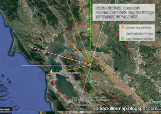
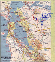
This does mean however I will have to upgrade the meridian I have already according Ramsom's coordinates.
http://www.clui.org/section/mount-diablo-meridian
The Bureau of Land Management (BLM) of the U.S. Department of the Interior maintains many records of
public lands which may be useful to the private surveyor. These records and the application of the public
lands system to California are described in some detail.
Initial Points in California
All public land surveys in California are referenced to three initial points as shown in Figure 1.
a. Humbolt in Northern California.
b. Mt. Diablo in Central California (east of San Francisco Bay).
c. San Bernardino in Southern California.
These are all at prominent mountain peaks visible for many miles.
In 1966, an expedition sponsored by the American Congress of Surveying and Mapping recovered all monuments and confirmed their location. They tied the points to the California Coordinate System and established a new geographical position for Washington's monument at longitude 116o 55'48.675" and latitude 34o 07'12.646
http://www.cpp.edu/~hturner/ce331/california.pdf
Ok, so the official contemporary Denning Monument Diablo coordinates are:
Benchmark: HS5120
This does mean however I will have to upgrade the meridian I have already according Ramsom's coordinates.
Mount Diablo Meridian
Most
Initial Points are created incidentally, as baselines (and sometimes
the meridians) are usually created first, with one end anchored on
relatively immutable geographic features, such as the confluence of
rivers, or latitudinal lines. The west has a number of exceptions, where
prominent peaks were selected to be Initial Points, and then base-lines
and meridians were drawn from them, as their visibility from great
distances aided the surveyor’s task. Such was the case with Mount
Diablo, an isolated mound rising above the surrounding valley, east of
the San Francisco Bay area. In 1851 it was selected to be the Initial
Point for the federal land surveys for northern California and Nevada.
An opening at the base of the column was provided to allow access to the exact spot from which the survey was conducted, marked now by a copper bolt head left from a 1876 triangulation station.Later research in the 1980s suggested that the copper bolt head, left exposed inside the center of the column, was actually from a coast and waterways survey started in 1852, and that the 1851 public lands survey mark, a small rectangular depression in the rock summit, is actually three feet northeast from the center of the pillar, a point that is now under the floor of the museum. If this is true, then the column, and the axis of the entire building, is off by 36 inches.
An opening at the base of the column was provided to allow access to the exact spot from which the survey was conducted, marked now by a copper bolt head left from a 1876 triangulation station.Later research in the 1980s suggested that the copper bolt head, left exposed inside the center of the column, was actually from a coast and waterways survey started in 1852, and that the 1851 public lands survey mark, a small rectangular depression in the rock summit, is actually three feet northeast from the center of the pillar, a point that is now under the floor of the museum. If this is true, then the column, and the axis of the entire building, is off by 36 inches.
http://www.clui.org/section/mount-diablo-meridian
The Bureau of Land Management (BLM) of the U.S. Department of the Interior maintains many records of
public lands which may be useful to the private surveyor. These records and the application of the public
lands system to California are described in some detail.
Initial Points in California
All public land surveys in California are referenced to three initial points as shown in Figure 1.
a. Humbolt in Northern California.
b. Mt. Diablo in Central California (east of San Francisco Bay).
c. San Bernardino in Southern California.
These are all at prominent mountain peaks visible for many miles.
In 1966, an expedition sponsored by the American Congress of Surveying and Mapping recovered all monuments and confirmed their location. They tied the points to the California Coordinate System and established a new geographical position for Washington's monument at longitude 116o 55'48.675" and latitude 34o 07'12.646
http://www.cpp.edu/~hturner/ce331/california.pdf
Ok, so the official contemporary Denning Monument Diablo coordinates are:
Benchmark: HS5120


Comments
Post a Comment